Welcome to course planning with Condes!
This page gives you a brief introduction.
Explore the available features, then continue with How to get a quick start and Introduction to on-screen course planning.
Anywhere in Condes, you can press F1 to get relevant "context sensitive" help.
Course planning with Condes Condes is a graphical editor that lets you draw your courses on top of a map shown on the screen. Condes helps with the tedious tasks. The program keeps track of controls and courses, and it prints the courses and maps as well as creates PDF and EPS files with the courses and maps.
Condes stores all the course planning data (controls, courses, classes, etc) for an orienteering event in a Condes event file (a .WCD file). You create controls, which can be combined into courses. The information about a control is shared among all the courses that visit the control. When you move the control, all courses are automatically updated. Data is always kept "consistent", and you can concentrate on the creative task of designing good courses.
An introduction to Condes features The following is a brief overview of some of the Condes features. |



Maps Condes uses map files, either an OCAD file, or a bitmap file (BMP/GIF/JPG/PNG/TIF), for example exported from Adobe Illustrator. Canvases An event file can use one or more "canvases", or "backgrounds" if you like. Canvases are used to design different graphics layouts for the same event, for example if you use maps at different scales, or print different parts of the map. You place a map on a canvas. The same map can be used on multiple canvases, allowing for different graphical layouts and/or different print scales. Or different maps can be used, allowing for a course that spans multiple maps. The same controls and courses can be shown on each canvas, by configuring canvases accordingly: •If a course extend across two maps, the two maps are placed on each their canvas. Each canvas then has the controls for the area covered by that canvas's map. •If you use two different maps of the same area, for example two maps at different map scales, they are placed on each their canvas and share the same controls and courses. |
Graphics Layout In addition to setting up the course on the map, Condes lets you add texts and graphics, so that you can compose an attractive layout, adapted for the event. You can add standard texts and free format texts. A standard text could be: course name, event name, map scale... i.e. texts that change depending on which course or map is used. For graphics, Bitmap files (BMP/GIF/JPG/PNG/TIF), Windows metafiles (EMF/WMF), and OCAD files (OCD) are supported. The map on a canvas can be used as the source of a graphics object. This allows you to create a layout using the texts and legends already in the map. It also allows you to place an enlarged portion of the map and course side by side with the original map. Refer to Adding an enlarged section of a map or Showing multiple parts of the course side-by-side. Control Descriptions can be printed on the map or separately, as pictorial or textual.
|
Course Planning
You plan your courses with the map on the screen. Condes helps you keep track of the control sites. Condes ensures that when you move a control, all the courses that use the control are kept up to date. Condes supports: •Individual courses (Foot orienteering, Ski orienteering, MTB orienteering, Trail orienteering) •Relay courses (regular forks (FARSTA) and leg forks) •Courses with loops (one-man relays, butterflies, diamonds (Phi)) •Calculates course lengths and control site loads •Shows attack angles for each control, unused controls etc. •Punch patterns for Emit backup slips (and for pin punches) •Printing course name and/or relay team number on the back of the map |
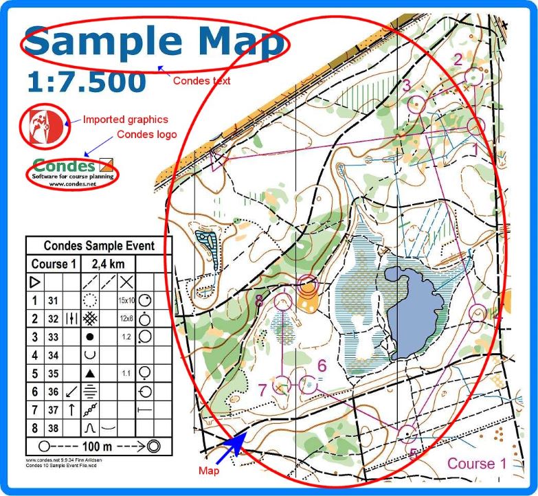
Map and Course Printing Condes can print the courses and maps directly on a color laser or ink jet printer. Alternatively, you can export to a PDF file, send the PDF file to a print shop for printing. Print Layouts Condes can print multiple maps on the same page. You can fill up the page with copies of the same course, or you can print different courses on the page. When you have complex events with map exchanges or courses to be printed at different map scales for different age groups, Condes support "Print Layouts". Print Layouts lets you configure for a course which map scale(s) to print at, and/or which course part(s) prints at which map. Overprint Effect Condes can print maps and courses with overprint effect, which improves map readability by allowing underlying details to be visible, that would otherwise be covered. As an alternative to using "overprint affect", Condes can "merge" the course overprint under the top map color layers. This alternative is recommended by the IOF for IOF events. More details: Overprint Effect or Upper/Lower Purple Relay Teams Handling In a spreadsheet style window, you can enter the relay teams, and you can assign course variations to each team member. Condes can "populate" the teams, or you can enter the course variations manually. Condes uses a sophisticated algorithm to ensure maximum variation between teams. When you have finalized the teams, you can: •export the teams to the event administration system for punch checking. •print individual maps for each team member, with the team number and leg number on the back of the page. Course Data Condes exchanges data with an event administration system •You can export course data for punch checking. •You can import relay teams from the event administration system, then assign course variations to team members, and export the relay teams with the assigned course variations back to the event administration system. The file format used is the IOF standard, XML based. |
Geo-referencing for GPS/tracking applications Condes exports maps and courses geo-referenced in KMZ format, SVG format or GPX format. These are formats used by popular GPS and tracking applications, such as O-Track, LiveLox, MapRun and GPS Orienteering. Exported PDF files are also geo-referenced, so that you can import them into for example Avenza Maps. Reports Condes can print listings of the information that is stored for an orienteering event: •All controls •All courses •All classes •Control/course relationship •Relay variations •Proposed relay team combinations Course Overprinting Condes prints the course onto an existing offset printed map. Course Layout Export Condes can export maps and courses in several different formats: •PDF format for digital and offset printing •EPS format for offset printing. •OCD format for import into OCAD, •BMP/JPG/PNG/TIF format for posting on the internet. •KMZ format for GPS applications (O-Track, Livelox and GPS Orienteering) •KML format for GPS applications (MapRun) •SVG format for GPS applications •GPX format for GPS applications
|